
The future map of Europe
PhD in Political Sciense, Head of Section
for Political Aspects of European Integration
of the RAS Institute of World Economy
and International Relations
People like both to play cards and look at maps. There is some similarity between them. We are enchanted by a hidden meaning, uncommon aesthetics and unlimited number of combinations they suggest. Besides, as it has turned out we can well play with the “serious” maps the way we play cards.
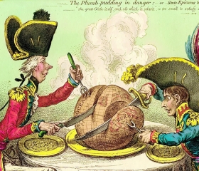
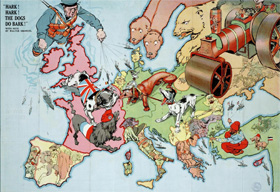
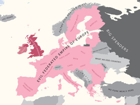
For example, you can move the countries to such places on the map where they would feel more comfortably. Imagination in combination with artistic skills will allow you to depict states as if they were human beings or animals, as it used to be popular with caricaturists in the early 20th century. If there are no artistic skills you can do pretty well with the imagination only wittingly renaming the existing states in such a way that they reflect common stereotypes. This typical approach could be combined with the redrawing of borders and forecasting efforts. It would be even more exciting to contemplate a series of bloody conflicts for the coming hundred years albeit marking them “designed for fun” in order to prevent grumbling comments.
A dangerous game
It’s easy to identify a joke in a YouTube video but it’s similarly easy to forget yourself playing with maps. Reality is usually distorted on a colorful sheet of paper crisscrossed with dotted lines. It might not be dangerous if a political map remains one of many elements that shape our vision of international relations although it happens sometimes to be the dominant one starting from childhood.
A child begins learning geography from studying the map of its own country. It discovers that the country has borders and neighbors. The reaction to this discovery can be different. Some will take it for granted; some will feel confused about these intricacies and limitations throughout their lifetime. In fact it happens so that behind many foreign policy dealings hide not urgent needs but rather an infantile wish to paint the map “your” color.
The map of Europe was repainted many times. These metamorphoses were far from virtual ones. They destroyed and determined the destinies of individuals and of peoples. At first, in the era of huge people’s masses movement across an almost uninhabited forested area the process of changes seemed quite natural. The vacuum was filled in no time but territory-thirsty rulers couldn’t grow quiet for centuries. The process reached its climax with the rise of colonial empires which collapsed under its own weight and the burden of numerous inherent conflicts. Having acquired tragic experience of the two world wars European powers were forced to admit the obvious – that the idea of the historical process should have been not the conquering of neighboring provinces but social and economic self-development.
An equilibrium
It was the dream of the philosophers of the Enlightenment and the following generation of intellectuals to give up territorial disputes and resolve conflicts peacefully. The UN Charter and later the Final Act of the Conference on Security and Cooperation in Europe with its principle of border integrity seemed to have translated this remarkable idea into political practice. The war in Yugoslavia revealed that the optimism was premature however this conflict might remain the repercussion of the past, the last bloodshed in the history of internal European wars.
Numerous changes that the map of Europe has undergone over centuries might make you think that the result obtained is pretty arbitrary. However, it is not so. The map has always sought to establish some balance between political and ethnic communities with policy desperately trying to influence the formation of national identity which in its turn affected policy.
Today’s Europe is as close as never before to a kind of equilibrium between the nations’ strive for political identity and the existing borders. European map is good enough to happily avoid further transformations. However, it’s not that difficult to identify potential trouble-makers.
Separatists and unionists
The candidates for establishing new independent states in Europe are well known.
Good “chances” has Scotland with its five million-strong population which could well belong to a group of such average EU countries as Denmark, Slovakia and Finland. The referendum on Scottish independence is to take place in autumn 2012. Catalonia with the population of seven million has almost the same chances. Three million - strong Basque country might carve its niche on the map of Europe between Spain and France. We cannot completely rule out the disintegration of Belgium into six million Flanders and francophone Wallonia with the population of 3.5 million people. It inevitably raises the issue of the EU capital – Brussels with a million, predominantly French-speaking, population. The list of dwarf island EU member-states could be extended by three hundred thousand-strong Corse following Malta and Cyprus. Despite the EU efforts to stabilize the situation in Bosnia and Herzegovina the country remains de-facto divided. The Federation of Bosnia and Herzegovina with the population of 2.3 million people may lose nearly 1.5 million-strong Republika Srpska. The region with 0.5 million Albanian population might break away from Macedonia. Greenland with its small population but vast territory could also claim independence. Currently the separation of Northern Italy inhabiting almost 28 or even 34 million people in line with “The League of the North” proposed Padania borders is being debated. Various theories have been proposed regarding hypothetical disintegration of Ukraine and Russia.
It should be noted, however, that the formation of newly independent states is possible only there where the conditions for holding and acknowledging the results of a peaceful referendum have been created. Confrontation and violent forms of fighting may ultimately hold separatists away from reaching their goals. As the cases of frozen conflicts in Cyprus, Transnistria and Transcaucasia suggest it may take decades to have the independence gained as a result of military actions recognized.
There are few in Europe who would want to create a bigger state out of some smaller ones. There are even fewer realistic projects in this regard and all of them actually reflect separatist trends. For example, Kosovo and Albanian regions of Macedonia could well merge with Albania thus increasing its population to 5.5 million. Republika Srpska would possibly like to unite with the seven million-strong Serbia. Flanders and the Netherlands are capable of making a single state with the population of 23 million people, while Wallonia may become the part of France.
 Thus, the map of Europe might accommodate 4-5 new independent states. We mean in the first place the regions which are already enjoying high degree of autonomy. At a regional level political life is getting on as usual, and justifiably it concerns the citizens more than political decisions taken in a far-away EU capital. The breakaway trends are stronger in the donor regions which are reluctant to allocate to the EU budget the money earned by the sweat on the brow, moreover if this money is given to support the least developed EU members. Actually, leaving tax revenues in regional budgets and consequently the shrinkage of the country’s resources losing its territory would lead to the main result in case independence is granted. None of the breakaway entities has the potential to play the role of a world’s political centre on its own. Therefore, their membership in the European Union would be of a principal importance for them. It would allow them to successfully deal with the limitations imposed on them by their modest demographic and territorial size.
Without internal borders
Europe in future is most likely to become more united but at the same time more fragmented and enlarged. To match the unmatchable will be possible due to the change of the interstate borders’ status which is taking place now. Apart from the symbolic meaning borders used to be the defense frontline in case of an aggression, a checkpoint, the boundary limiting the jurisdiction of a state and a customs point.
 Trade and economic barriers in the European area give way to free movement of goods, services, capital and persons. Countries – members to the Schengen Agreement have gone even further sacrificing any control at the internal borders. What remains is the challenge of common defense of the EU external borders – this time round not against an aggressor but against the inflow of migrants from the least developed regions of the world and trans-national crime – and delimitation of the jurisdiction. National legislations in this case turn out to be one of the tiers of the sophisticated system including international conventions, expanding EU Aquis Communitaire and legal regulations adopted at regional and municipal levels. Under these conditions more attention has to be drawn to the map showing borders between EU member-states, EU candidate-states and EU non-member states. The changing of the map may appear to be much more important than the hypothetical independence of Scotland or Catalonia.
The EU enlargement has slowed down. Before the process continues the EU has to overcome the negative effects of the crisis and to upgrade the level of the economic development of the poorest member-states to the EU-average. In 10-15 years time the problem will be solved. It is only then that the Balkan states remaining outside the European Union and Moldova will become its full-fledged members. In another 15-20 years there will possibly emerge an integration entity uniting the enlarged EU with Turkey, Ukraine, Belarus, Russia, Kazakhstan and the countries of Transcaucasia. By the time the sentiments might have changed in Switzerland, Norway and Iceland currently skeptical about their membership in the EU.
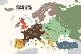 Regional integration is not a one-time solution but a process. To a different extent all European countries participate in it either directly or through the system of bilateral agreements with the EU or its members. At a certain stage the quantity of intra-regional ties transform into the qualitative factor which is currently the membership in the EU. In 35-40 years time the integration mechanisms will inevitably change. A new union treaty, new voting rules and economic instruments will be needed. But what will remain is the demand for the European unity. Common European market and the single European voice could represent on the international arena about 900 million people – an impressive number albeit not surprising even today especially in the context of the forecasted by 2050 5 billion Asia, nearly 2 billion Africa and 1,2 billion populating Western hemisphere.
However, the future map painted with only one color from Lisbon to Vladivostok would be too schematic. As the EU experience suggests that free movement and a free market have eliminated neither language and cultural differences nor religious peculiarities. Integration relies on the principle of subsidiarity – only those powers that cannot be effectively exercised at a lower level must be delegated to the upper one. The lion’s share of the problems resolved through political mechanisms can and must be dealt with by regional authorities. Hence, the importance of a fanciful map of the European regions which is unlikely to change dramatically with years reminding of the diversity that is the main strength of the Old World.
***
Modern technologies help to increase the scope of information communicated by a map. And it is not so much important whether this or that separatist project is implemented. What is important is that our vision of Europe should become multi-dimensional. The future map of Europe is the map of common European decision-making bodies, joint infrastructure projects, optimized distribution of industrial facilities, mutual investments, transportation flows moving freely across the borders. It is also the map of tens of thousands municipalities somewhat different from each other. The task for the European politicians of the future is to realize and maximally use the competitive advantages of the region and finally give up the already irrelevant game of redrawing dotted borderlines on the map.
Source: russiancouncil.ru / economist.com


0 comments :